
About Sado Island
Find out about geological features and the making of Sado Island!

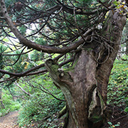
Landforms and the Natural Environment


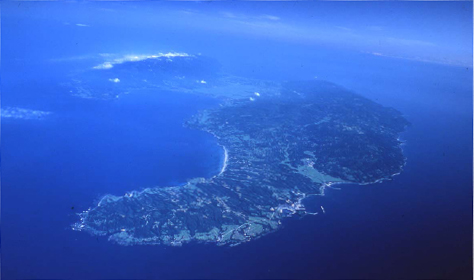
Sado is the largest island in the Sea of Japan and the only one that has mines. The island is traversed by the Osado Mountain Range and the Kosado Hills from northeast to southwest, and between the two ranges is the grain belt of Kuninaka Plain.
Located to the north of the Osado area is Sado Ridge, and on the west of the island is Toyama Trough. The area stretching from the Itoigawa-Shizuoka Tectonic Line (which separates the area into east and west halves) through the west of Sado to around Okushiri Island in Hokkaido is called the Eastern Margin of the Japan Sea, which is known as an earthquake-prone region.
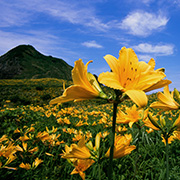
Due to the warm current flowing off the coast of the island (Tsushima Warm Current), Sado actually has cooler summers and warmer winters than mainland Niigata. Blessed with abundant nature, the island and the surrounding sea make a great natural habitat for a myriad of plants and marine wildlife. Large portions of the island are designated as parts of national and quasi-national parks. In the mountains, there is a mysterious pond that has the largest floating island of Japan’s high marshy wetlands.

Sado Island as a Geopark
The making of Sado Island
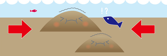
Sado is the largest remote island in the Sea of Japan. However, it was not always located where it is now. The land forming Sado Island was in fact the tip of a continent that drifted across Earth over a long time.
The formation of Sado Island can be divided into three periods:
- 1. Continent Era
- 2. Ocean Era
- 3. Uplift Era
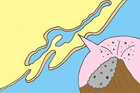
Continent Era
In the ancient past, Sado Island was not where it is now and used to be part of a continent crust. The edge of the continent began cracking and the broken parts began to separate from the continent. At that time there were intense volcanic eruptions.
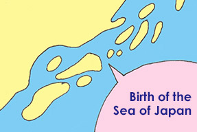
Ocean Era
The edge broke free of the continent, and seawater poured in between the broken edge and the continent. Thus, the Sea of Japan was formed and became deeper and deeper. At that time, the land of what would become modern Sado was part of the ocean floor.
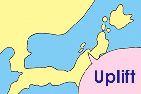
Uplift era
Tremendous stresses built up on the ocean floor, triggering uplift of the seabed which would become Sado Island. Sado is, therefore, an island formed by uplift.
(日本語) 第4ステージ 島の時代(300万年前~現在)
① The land of what would become modern Sado experienced immense pressure from within the Earth.
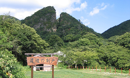
Sado Geopark
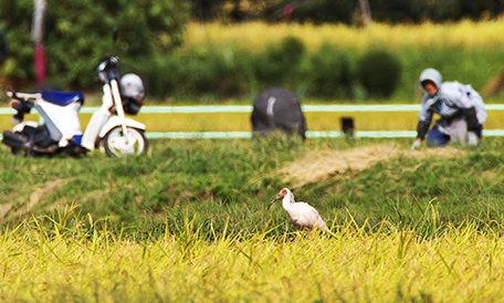
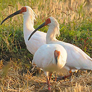
The landscape, featuring a plain in the middle of the island, was formed over a very long time. Paddy fields spread across the plain, providing a home for biodiversity, including Toki, the Japanese crested ibises.
Rocks formed during the volcanic activities in ancient times underpin the island and brought gold and silver veins which were mined, creating the largest production in Japan.
Sado’s geology and landscapes are closely linked to our lives, as well as those of plants and animals. At Sado Geopark, you can enjoy the story of the connections between humans and the land.
(日本語) 佐渡ジオパークの境界線
(日本語) 佐渡島の海岸線がジオパークエリアの境界線(次の地図に赤で示した線)です。
その境界線の内側が佐渡ジオパークのエリアであり、佐渡ジオパークのエリアは、佐渡市の市域と一致しています。
佐渡ジオパークのロゴマーク
ロゴマークに秘められた想い
佐渡ジオパークのロゴマークには、それぞれの色と形に意味があります。赤色は佐渡市の鳥でもあるトキを、黄色は佐渡の花と金銀を、緑色は佐渡の自然を、そして青色は佐渡の海の色、その形は伝統芸能でもある鬼太鼓の巴を意味し、大地・自然・生きもの・文化すべてが佐渡ジオパークの要素であることを示しています。
 赤
赤
 黄
黄
 緑
緑
 青
青
What is a Geopark?
The word “geopark” is a blend of geography and park. A geopark must protect and conserve abundant natural landscapes of geographical significance and scientific value, as well as use the geological resources in the community. Driven by a love of nature, we utilize our natural heritage through education, ecotourism, and the promotion of sustainable local revitalization.
While Japan has Japanese National Geoparks designated by the Japan Geopark Committee (JGC), there are also UNESCO Global Geoparks designated by UNESCO. Designated geoparks are revalidated every four years. Their suitability and activity records are examined in order to ensure that their functionality and quality maintain the high standard associated with the designation, and that they are committed to further improvement.
In Japan, there are 10 UNESCO Global Geoparks including Itoigawa (Niigata Prefecture) and Toya-Usu (Hokkaido). The Japanese Geoparks Network has 46 members including Sado (as of May 2023). There are 53 areas that have begun their geopark activities or aspire to become a geopark are included.
For more details, please visit the Japanese Geoparks Network website.
After being designated as a Japanese Geopark in the autumn of 2013, Sado has embarked on a variety of activities.
Sado's Quasi-National Parks and Natural Monuments plus Other Places to Note
| Quasi-National Park | Sado-Yahiko-Yoneyama Quasi-National Park (1950) |
|---|---|
| National Natural Monument / National Place of Scenic Beauty | Sado Ogi Coast (1934) |
| National Place of Scenic Beauty | Sado Kaifu Coast (1934) |
| National Natural Monument | Marine Potholes of Hiranezaki (1940), Goshozakura cherry trees in Ogi (1928), etc. |
| National Historic Site | Sado Gold and Silver Mine (renamed in 2011) |
| National Special Natural Monument | Toki Japanese crested ibises (1952) |
| Japan's 100 Geological Features | Sado Gold Mine (2007), Sado Ogi Coast (2007) |
| Prefectural Natural Park | Kosado Prefectural Natural Park (1959) |
| Prefectural Nature Conservation Area | Uenodaira Prefectural Nature Conservation Area (1989) |
| Prefectural Natural Monuments | Floating Island in Otowaike Pond and plant community (1963), Sugiike Pond and deciduous trees (1965), Gold ore in Sado Deposit (1958), etc. |
| Prefectural Natural Monument / Prefectural Place of Scenic Beauty | Daigahana (1973) |
| Prefectural Historic Site | Niibo Tamatsukuri Ruins (1952), Grave of Shizume Ichizaemon, Deputy for Sado (1958), Iwayasan Cave (1972), etc. |
| Sado City's Natural Monument | Sawane Kaidate Formation (2004), Seki "Mirror Rock" (fault mirror) (2004) |
| Sado City's Place of Scenic Beauty / Sado City's Natural Monument | Sawane Cliffs (2004) |
Sado Geopark Promotion Council
Contact
232 Chigusa,Sado,Niigata,952-1292
TEL. +81-259-63-5140
FAX. +81-259-63-5124
mail. sado-geopark@city.sado.niigata.jp
Sado Island Geopark information Center
2nd Floor,Sado Island Development Center,198 Ryotsu Minato,Sado,Niigata,952-8501
TEL. +81-259-27-2162
FAX. +81-259-58-7357
